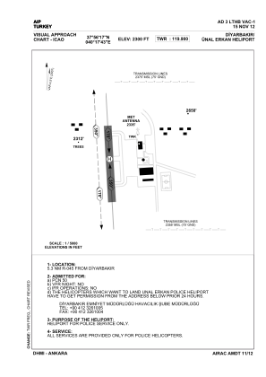
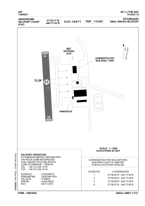


LTHB - Diyarbakir Unal Erkan Police Heliport
Located in Diyarbakir, Turkey
ICAO - , IATA -
Data provided by AirmateGeneral information
Coordinates: N37°56'17" E40°17'43"
Elevation is 2300 feet MSL.
Magnetic variation is 4.29° East View others Airports in Diyarbakir
Operational data
Special qualification required
Current time UTC:
Current local time:
Weather at : LTCC - Diyarbakir ( 10 km )
METAR: LTCC 172020Z 33009KT 9999 FEW040 18/08 Q1016 NOSIG RMK RWY16 34010KT 280V350 2CU040
TAF: TAF LTCC 171640Z 1718/1818 VRB02KT 9999 SCT040 BECMG 1720/1723 CAVOK BECMG 1808/1811 SCT040 PROB40 TEMPO 1816/1818 -TSRA FEW025CB BKN035
Communications frequencies: [VIEW]
Runways:
Airport contact information
Address: Diyarbakir Turkey