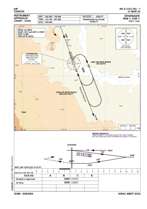
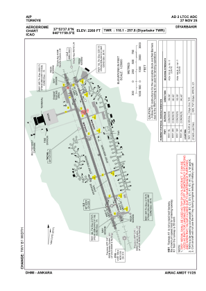


LTCC - Diyarbakir
Located in Diyarbakir, Turkey
ICAO - LTCC, IATA - DIY
Data provided by AirmateGeneral information
Coordinates: N37°53'37" E40°11'59"
Elevation is 2260 feet MSL.
Magnetic variation is 5.6° East View others Airports in Diyarbakir
Operational data
Special qualification required
Current time UTC:
Current local time:
Weather
METAR: LTCC 291620Z 02004KT CAVOK 26/08 Q1013 NOSIG RMK RWY16 VRB02KT SKC
TAF: TAF LTCC 291040Z 2912/3012 VRB02KT CAVOK
Communications frequencies: [VIEW]
Runways:
| RWY identifier | QFU | Length (ft) | Width (ft) | Surface | LDA (ft) |
| 16R | 163° | 11644 | 148 | CONC | 11644 |
| 34L | 343° | 11644 | 148 | CONC | 11644 |
| 16L | 163° | 11644 | 148 | CONC | 11644 |
| 34R | 343° | 11644 | 148 | CONC | 11644 |
Airport contact information
Address: Diyarbakir Turkey