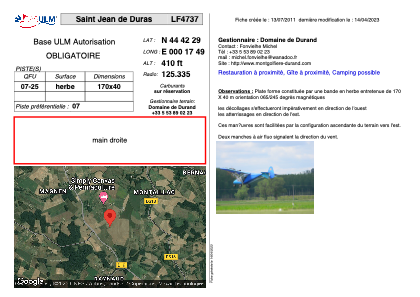


LF4737 - Saint Jean de Duras
Located in Saint-Jean-de-Duras, France
ICAO - , IATA -
Data provided by AirmateGeneral information
Coordinates: N44°42'29" E0°17'49"
Elevation is 410 feet MSL.
View others Airports in Aquitaine
Operational data
Special qualification required
Current time UTC:
Current local time:
Weather at : LFBE - Bergerac Dordogne Perigord ( 22 km )
METAR: LFBE 140430Z AUTO 26006KT 7000 RA //////CB 12/11 Q1007 BECMG NSW SCT015 BKN025
TAF: TAF LFBE 132300Z 1400/1424 29010KT 9999 SCT015 BKN025 TEMPO 1400/1405 4500 -RA BKN008 BKN015CB BECMG 1405/1407 20005KT TEMPO 1411/1421 3000 SHRA BKN010 BKN025TCU PROB30 TEMPO 1413/1416 1400 -TSRA BKN010 BKN025CB BECMG 1421/1423 CAVOK
Communications frequencies: [VIEW]
Runways:
| RWY identifier | QFU | Length (ft) | Width (ft) | Surface | LDA (ft) |
| 07 | 0° | 557 | 131 | GRASS | |
| 25 | 0° | 557 | 131 | GRASS |
Airport contact information
Address: Saint-Jean-de-Duras France