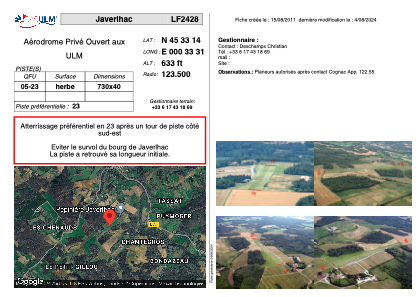


LF2428 - Javerlhac
Located in Javerlhac-et-la-Chapelle-Saint-Robert, France
ICAO - , IATA -
Data provided by AirmateGeneral information
Coordinates: N45°33'14" E0°33'31"
Elevation is 633 feet MSL.
View others Airports in Poitou-Charentes
Operational data
Special qualification required
Current time UTC:
Current local time:
Weather at : LFBU - Angouleme Brie Champniers ( 33 km )
METAR: LFBU 120730Z AUTO 19004KT 160V230 9999 FEW019 BKN076 BKN092 16/15 Q1017 TEMPO 4000 SHRA BKN010 BKN050TCU
TAF: TAF LFBU 120500Z 1206/1306 21005KT CAVOK TEMPO 1206/1216 4000 SHRA BKN010 BKN050TCU BECMG 1216/1218 BKN020
Communications frequencies: [VIEW]
Runways:
Airport contact information
Address: Javerlhac-et-la-Chapelle-Saint-Robert France