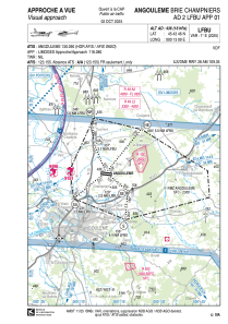
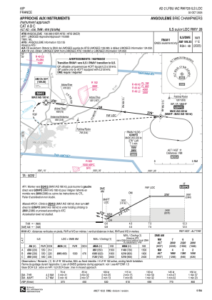
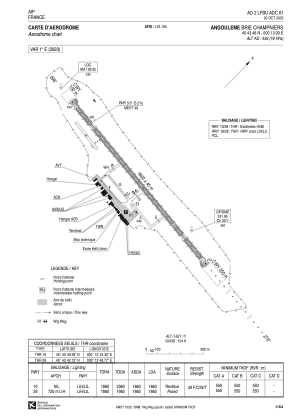


LFBU - Angouleme Brie Champniers
Located in Angouleme, France
ICAO - LFBU, IATA - ANG
Data provided by AirmateGeneral information
Coordinates: N45°43'46" E0°13'9"
Elevation is 436 feet MSL.
Magnetic variation is 0.56° East View others Airports in Poitou-Charentes
Operational data
Special qualification required
Current time UTC:
Current local time:
Weather
METAR: LFBU 281700Z AUTO VRB02KT 9999 ///CB ///// Q1015 TEMPO 24015G25KT 2000 SHRA BECMG NSC
TAF: TAF LFBU 281100Z 2812/2912 24010KT 9999 SCT040 PROB40 TEMPO 2812/2818 24015G25KT 2000 SHRA BKN030TCU BECMG 2818/2820 VRB03KT CAVOK BECMG 2822/2824 2500 BR TEMPO 2902/2908 0300 FG VV/// BECMG 2908/2910 CAVOK
Communications frequencies: [VIEW]
Runways:
| RWY identifier | QFU | Length (ft) | Width (ft) | Surface | LDA (ft) |
| 10 | 97° | 6102 | 148 | ASPH | 6102 |
| 28 | 277° | 6102 | 148 | ASPH | 6102 |
Airport contact information
Address: Angouleme France
