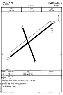


KATA - Hall-Miller Muni
Located in Atlanta, United States
ICAO - ATA, IATA -
Data provided by AirmateGeneral information
Coordinates: N33°6'9" W94°11'42"
Elevation is 280 feet MSL.
Magnetic variation is 04° East View others Airports in Texas
Operational data
Special qualification required
Current time UTC:
Current local time:
Weather at : KTXK - Texarkana Rgnl-Webb Fld ( 43 km )
METAR: KTXK 210453Z AUTO 16009KT 10SM CLR 27/20 A2984 RMK AO2 SLP098 T02670200
TAF: KTXK 202320Z 2100/2124 16010KT P6SM SCT050 FM210600 16005KT P6SM SCT250 FM211100 17005KT P6SM FEW025 SCT250 TEMPO 2112/2115 P6SM BKN015 FM211600 18010KT P6SM BKN035 FM212000 18010KT P6SM BKN050
Communications frequencies: [VIEW]
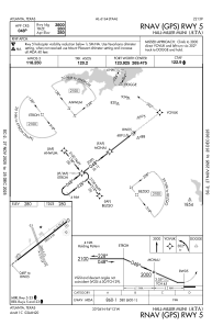
Runways:
| RWY identifier | QFU | Length (ft) | Width (ft) | Surface | LDA (ft) |
| 05 | 52° | 3800 | 60 | ASPH | |
| 23 | 232° | 3800 | 60 | ASPH | |
| 15 | 160° | 2264 | 75 | GRASS | |
| 33 | 340° | 2264 | 75 | GRASS |
Airport contact information
Address: Atlanta United States