


KTXK - Texarkana Rgnl-Webb Fld
Located in Texarkana, United States
ICAO - TXK, IATA - TXK
Data provided by AirmateGeneral information
Coordinates: N33°27'13" W93°59'28"
Elevation is 389 feet MSL.
Magnetic variation is 05° East View others Airports in Arkansas
Operational data
Special qualification required
Current time UTC:
Current local time:
Weather
METAR: KTXK 301703Z VRB03KT 10SM BKN028 27/18 A2999 RMK AO2 T02670183
TAF: KTXK 301121Z 3012/0112 00000KT 1/4SM FG VV002 FM301500 10002KT 6SM BR SKC FM301800 17006KT P6SM SCT035 FM010000 16004KT P6SM SKC FM010600 17004KT P6SM SCT250
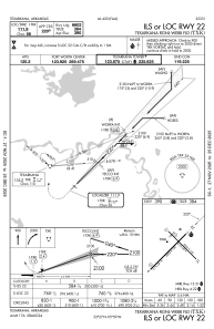
Communications frequencies: [VIEW]
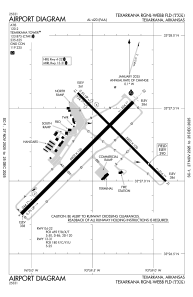
Runways:
| RWY identifier | QFU | Length (ft) | Width (ft) | Surface | LDA (ft) |
| 04 | 45° | 6602 | 150 | ASPH | 6602 |
| 22 | 225° | 6602 | 150 | ASPH | 6602 |
| 13 | 135° | 5200 | 100 | ASPH | 4559 |
| 31 | 315° | 5200 | 100 | ASPH | 4559 |
Airport contact information
Address: Texarkana United States
