


YWWL - West Wyalong
Located in West Wyalong, Australia
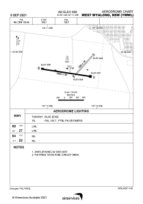
ICAO - YWWL, IATA - WWY
Data provided by AirmateGeneral information
Coordinates: S33°56'14" E147°11'29"
Elevation is 859 feet MSL.
View others Airports in New South Wales
Operational data
Special qualification required
Current time UTC:
Current local time:
Weather at : - ( 0 km )
METAR: PABA 190752Z 09025KT 9SM OVC009 M02/M03 A3014 RMK AO2 PK WND 09029/0749 SNB22E35 SLP212 T10221033 FZRANO PNO $
Communications frequencies: [VIEW]
Runways:
| RWY identifier | QFU | Length (ft) | Width (ft) | Surface | LDA (ft) |
| 04 | 42° | 2559 | 59 | GVL | |
| 22 | 222° | 2559 | 59 | GVL | |
| 09 | 99° | 5200 | 98 | ASP | |
| 27 | 279° | 5200 | 98 | ASP |
Airport contact information
Address: West Wyalong Australia