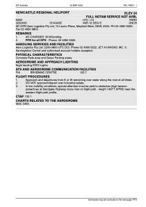


YNRH - Newcastle Regional Heliport
Located in Mayfield West, Australia
ICAO - YNRH, IATA - PHJ
Data provided by AirmateGeneral information
Coordinates: S32°52'46" E151°43'43"
Elevation is 20 feet MSL.
View others Airports in New South Wales
Operational data
Special qualification required
Current time UTC:
Current local time:
Weather at : YWLM - Williamtown ( 14 km )
METAR: YWLM 172030Z AUTO 21015KT 9999 // SCT022 BKN032 BKN040 15/12 Q1020
TAF: TAF AMD YWLM 171708Z 1718/1818 20020G30KT 9999 -SHRA SCT015 BKN020 FM180200 20022KT 9999 -SHRA SCT030 FM181000 21010KT 9999 NSW SCT020 INTER 1718/1800 19020G35KT 4000 SHRA BKN010 INTER 1800/1810 18020G30KT 2000 SHRA BKN012 SCT030TCU INTER 1810/1812 20015G25KT 4000 SHRA BKN012
Communications frequencies: [VIEW]
Runways:
Airport contact information
Address: Mayfield West Australia