


X51 - Miami Homestead General Aviation
Located in Homestead, United States
ICAO - X51, IATA -
Data provided by AirmateGeneral information
Coordinates: N25°29'57" W80°33'15"
Elevation is 7 feet MSL.
Magnetic variation is -06° East View others Airports in Florida
Operational data
Special qualification required
Current time UTC:
Current local time:
Weather at : KHST - Homestead Arb ( 17 km )
METAR: KHST 122341Z AUTO 09007KT 10SM FEW019 28/23 A2989 RMK AO2 DZE03DZB13E41 SLP125
TAF: TAF KHST 121900Z 1219/1401 05012KT 9999 FEW025 SCT150 QNH2989INS BECMG 1223/1224 VRB06KT 9999 FEW020 FEW040 SCT150 QNH2991INS BECMG 1317/1318 14008KT 9999 SCT025 BKN040 BKN200 QNH2988INS BECMG 1323/1324 VRB06KT 9999 NSW SCT025 BKN055 QNH2988INS TX33/1219Z TN23/1311Z
Communications frequencies: [VIEW]
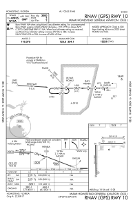
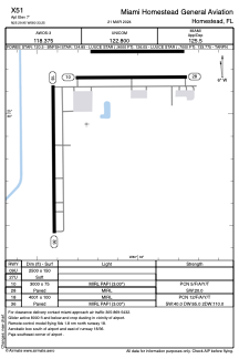
Runways:
| RWY identifier | QFU | Length (ft) | Width (ft) | Surface | LDA (ft) |
| 09U | 0° | 2500 | 150 | GRASS | |
| 27U | 0° | 2500 | 150 | GRASS | |
| 10 | 90° | 3000 | 75 | ASPH | |
| 28 | 270° | 3000 | 75 | ASPH | |
| 18 | 179° | 4001 | 100 | ASPH | |
| 36 | 359° | 4001 | 100 | ASPH | |
| 09 | 0° | 2500 | 150 | UNK | |
| 27 | 0° | 2500 | 150 | UNK |
Airport contact information
Address: Homestead United States
Other aviation service providers
Flight schools

Pilot Training Center Homestead
Pilot Training Center Homestead
bryan@pilottrainingcenterhomestead.com+1(786)309-2359