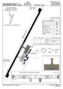


WIPO - Way Kanan / Gatot Soebroto
Located in Way Kanan, Indonesia
ICAO - WIPO, IATA -
Data provided by AirmateGeneral information
Coordinates: S4°23'38" E104°24'10"
Elevation is 350 feet MSL.
View others Airports in Lampung
Operational data
Special qualification required
Current time UTC:
Current local time:
Weather at : - ( 0 km )
METAR: KW96 092235Z AUTO 00000KT 10SM SCT044 BKN060 OVC100 25/18 A2959 RMK AO1 T02510180
Communications frequencies: [VIEW]
Runways:
| RWY identifier | QFU | Length (ft) | Width (ft) | Surface | LDA (ft) |
| 03 | 29° | 6890 | 131 | ASP | |
| 21 | 209° | 6890 | 131 | ASP |
Airport contact information
Address: Way Kanan Indonesia