


WAWW - Kendari / Halu Oleo
Located in Kendari, Indonesia
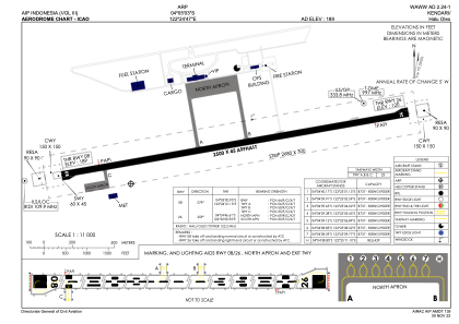
ICAO - WAWW, IATA - KDI
Data provided by AirmateGeneral information
Coordinates: S4°5'3" E122°24'47"
Elevation is 189 feet MSL.
View others Airports in Sulawesi Tenggara
Operational data
Special qualification required
Current time UTC:
Current local time:
Weather at : - ( 0 km )
METAR: SBBG 271810Z AUTO 15014KT 9999 -RA BKN005 OVC011 17/17 Q1007 RERA
Communications frequencies: [VIEW]
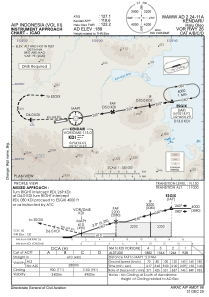
Runways:
| RWY identifier | QFU | Length (ft) | Width (ft) | Surface | LDA (ft) |
| 08 | 80° | 8202 | 148 | ASP | |
| 26 | 260° | 8202 | 148 | ASP |
Airport contact information
Address: Kendari Indonesia