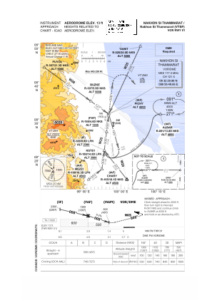
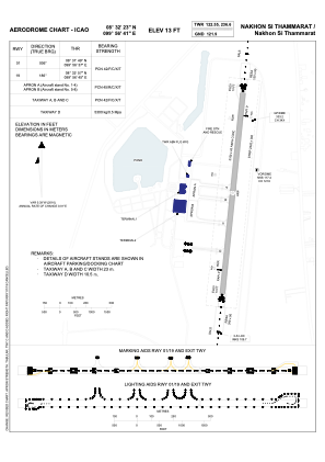


VTSF - Nakhon Si Thammarat / Nakhon Si Thammarat Airport
Located in Nakhon Si Thammarat, Thailand
ICAO - VTSF, IATA - NST
Data provided by AirmateGeneral information
Coordinates: N8°32'23" E99°56'41"
Elevation is 13 feet MSL.
View others Airports in Nakhon Si Thammarat Province
Operational data
Special qualification required
Current time UTC:
Current local time:
Weather
METAR: VTSF 160400Z 35005KT 320V020 3000 TSRA FEW016CB BKN018 BKN020 25/25 Q1010 RERA NOSIG
TAF: TAF VTSF 152300Z 1600/1624 30003KT 9999 FEW020 BECMG 1604/1606 08010KT TEMPO 1606/1612 VRB15G25KT 4000 TSRA FEW016CB SCT018 BKN100 BECMG 1613/1615 30003KT
Communications frequencies: [VIEW]
Runways:
| RWY identifier | QFU | Length (ft) | Width (ft) | Surface | LDA (ft) |
| 01 | 6° | 6890 | 148 | ASP | |
| 19 | 186° | 6890 | 148 | ASP |
Airport contact information
Address: Nakhon Si Thammarat Thailand