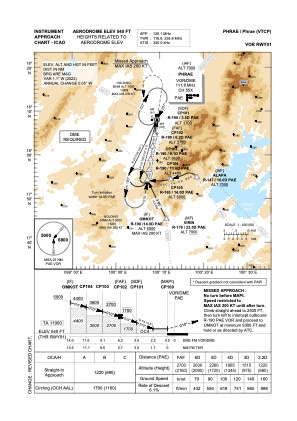
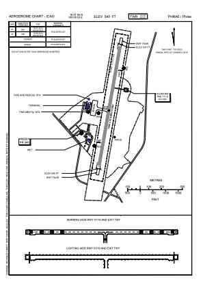


VTCP - Phrae / Phrae Airport
Located in Phrae, Thailand
ICAO - VTCP, IATA - PRH
Data provided by AirmateGeneral information
Coordinates: N18°7'54" E100°9'53"
Elevation is 538 feet MSL.
View others Airports in Phrae Province
Operational data
Special qualification required
Current time UTC:
Current local time:
Weather
METAR: VTCP 130600Z VRB03KT 9999 FEW025CB 37/23 Q1008 NOSIG
TAF: TAF VTCP 130500Z 1306/1406 01005KT 9999 SCT035 TEMPO 1306/1312 27015G25KT 4000 TSRA FEW020CB BKN030 TEMPO 1314/1320 30015G25KT 4000 TSRA FEW020CB BKN030
Communications frequencies: [VIEW]
Runways:
| RWY identifier | QFU | Length (ft) | Width (ft) | Surface | LDA (ft) |
| 01 | 5° | 4921 | 98 | ASP | |
| 19 | 185° | 4921 | 98 | ASP |
Airport contact information
Address: Phrae Thailand