


VOHY - Hyderabad International Airport, Hyderabad
Located in Hyderabad, India
ICAO - VOHY, IATA - BPM
Data provided by AirmateGeneral information
Coordinates: N17°27'12" E78°27'45"
Elevation is 1744 feet MSL.
View others Airports in Andhra Pradesh
Operational data
Special qualification required
Current time UTC:
Current local time:
Weather
METAR: VOHY 081430Z 11007KT 6000 FEW020 31/22 Q1001 NOSIG
TAF: TAF VOHY 081400Z 0815/0824 12010KT 6000 SCT015 SCT025 TEMPO 0818/0822 25010KT 3000 .TSRA SCT015 SCT025 FEW030CB
Communications frequencies: [VIEW]
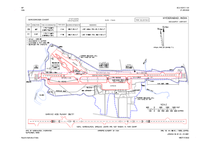
Runways:
| RWY identifier | QFU | Length (ft) | Width (ft) | Surface | LDA (ft) |
| 09 | 89° | 10597 | 148 | ASP | |
| 27 | 269° | 10597 | 148 | ASP |
Airport contact information
Address: Hyderabad India