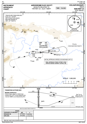
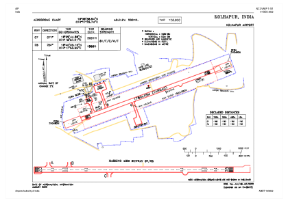


VAKP - Kolhapur Airport
Located in Kolhapur, India
ICAO - VAKP, IATA - KLH
Data provided by AirmateGeneral information
Coordinates: N16°39'59" E74°17'26"
Elevation is 1996 feet MSL.
View others Airports in Maharashtra
Operational data
Special qualification required
Current time UTC:
Current local time:
Weather
METAR: VAKP 280600Z 02005KT 7000 NSC 36/13 Q1012
TAF: TAF VAKP 280500Z 2806/2815 35011KT 5000 FU FEW020 BECMG 2807/2809 33010KT FEW020 SCT025 BECMG 2612/2614 04008KT 3000 HZ FEW020 SCT100
Communications frequencies: [VIEW]
Runways:
| RWY identifier | QFU | Length (ft) | Width (ft) | Surface | LDA (ft) |
| 07 | 70° | 5840 | 148 | ASP | |
| 25 | 250° | 5840 | 148 | ASP |
Airport contact information
Address: Kolhapur India