


T54 - Lane Airpark
Located in Rosenberg, United States
ICAO - T54, IATA -
Data provided by AirmateGeneral information
Coordinates: N29°31'24" W95°46'47"
Elevation is 94 feet MSL.
Magnetic variation is 05° East View others Airports in Texas
Operational data
Special qualification required
Current time UTC:
Current local time:
Weather at : KSGR - Sugar Land Rgnl ( 16 km )
METAR: KSGR 161753Z 14014KT 10SM OVC020 29/25 A2970 RMK AO2 SLP057 T02890250 10289 20239 56014
TAF: KSGR 161730Z 1618/1718 14013G22KT P6SM VCSH SCT015 BKN020 FM162200 15015G23KT 4SM -SHRA BR VCTS SCT008 OVC015CB TEMPO 1702/1705 VRB20G30KT 2SM TSRA BR BKN008CB FM170500 06008KT 5SM BR VCSH OVC007 FM170700 VRB05KT 4SM BR OVC007 FM171600 VRB06KT P6SM BKN015 OVC020
Communications frequencies: [VIEW]
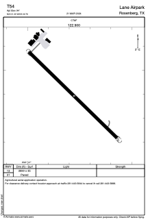
Runways:
| RWY identifier | QFU | Length (ft) | Width (ft) | Surface | LDA (ft) |
| 13 | 0° | 2890 | 35 | ASPH | |
| 31 | 0° | 2890 | 35 | ASPH |
Airport contact information
Address: Rosenberg United States