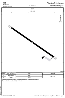


T05 - Charles R Johnson
Located in Port Mansfield, United States
ICAO - T05, IATA -
Data provided by AirmateGeneral information
Coordinates: N26°33'37" W97°26'21"
Elevation is 10 feet MSL.
Magnetic variation is 07° East View others Airports in Texas
Operational data
Special qualification required
Current time UTC:
Current local time:
Weather at : KHRL - Valley Intl ( 43 km )
METAR: KHRL 152252Z 11015KT 6SM HZ FEW023 SCT028 OVC038 31/25 A2968 RMK AO2 SLP049 T03060250
TAF: KHRL 152337Z 1600/1624 11015G23KT P6SM SCT025 BKN040 FM160100 11014G22KT P6SM BKN016 FM161500 15013G21KT P6SM BKN016 FM161800 16016G25KT P6SM SCT030
Communications frequencies: [VIEW]
Runways:
| RWY identifier | QFU | Length (ft) | Width (ft) | Surface | LDA (ft) |
| 12 | 124° | 3200 | 50 | ASPH | |
| 30 | 304° | 3200 | 50 | ASPH |
Airport contact information
Address: Port Mansfield United States