


T05 - Charles R Johnson
Located in Port Mansfield, United States
ICAO - T05, IATA -
Data provided by AirmateGeneral information
Coordinates: N26°33'37" W97°26'21"
Elevation is 10 feet MSL.
Magnetic variation is 07° East View others Airports in Texas
Operational data
Special qualification required
Current time UTC:
Current local time:
Weather at : KHRL - Valley Intl ( 43 km )
METAR: KHRL 021831Z 14011KT 10SM BKN024 BKN031 OVC039 29/24 A2968 RMK AO2 T02890239
TAF: KHRL 021720Z 0218/0318 16013KT P6SM OVC021 FM022100 16013KT P6SM BKN040 FM030300 13011KT P6SM BKN012 FM030600 15011KT P6SM OVC007 FM031700 12011KT P6SM BKN018
Communications frequencies: [VIEW]
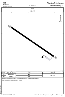
Runways:
| RWY identifier | QFU | Length (ft) | Width (ft) | Surface | LDA (ft) |
| 12 | 124° | 3200 | 50 | ASPH | |
| 30 | 304° | 3200 | 50 | ASPH |
Airport contact information
Address: Port Mansfield United States