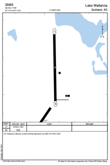


SN65 - Lake Waltanna
Located in Goddard, United States
ICAO - SN65, IATA -
Data provided by AirmateGeneral information
Coordinates: N37°35'39" W97°36'56"
Elevation is 1448 feet MSL.
Magnetic variation is 07° East View others Airports in Kansas
Operational data
Special qualification required
Current time UTC:
Current local time:
Weather at : KICT - Wichita Dwight D Eisenhower Ntl ( 17 km )
METAR: KICT 271653Z 17018G28KT 9SM BKN027 OVC033 23/19 A2972 RMK AO2 PK WND 19028/1637 LTG DSNT SE AND S SLP055 T02280189
TAF: KICT 271120Z 2712/2812 18015G24KT P6SM BKN015 FM271700 18015G23KT P6SM VCTS FEW015 BKN025CB TEMPO 2717/2720 1SM TSRA BKN015CB FM272000 18019G28KT P6SM BKN025 PROB30 2722/2802 26035G50KT 1SM +TSRA BR OVC010CB
Communications frequencies: [VIEW]
Runways:
| RWY identifier | QFU | Length (ft) | Width (ft) | Surface | LDA (ft) |
| 17 | 179° | 2100 | 100 | GRASS | |
| 35 | 359° | 2100 | 100 | GRASS |
Airport contact information
Address: Goddard United States