


KICT - Wichita Dwight D Eisenhower Ntl
Located in Wichita, United States
ICAO - ICT, IATA - ICT
Data provided by AirmateGeneral information
Coordinates: N37°38'60" W97°25'59"
Elevation is 1332 feet MSL.
Magnetic variation is 04° East View others Airports in Kansas
Operational data
Special qualification required
Current time UTC:
Current local time:
Weather
METAR: KICT 272128Z 11013KT 10SM SCT075 BKN095 17/14 A2967 RMK AO2 PK WND 09027/2054 RAE18 TSE26 OCNL LTGICCC DSNT NE-E TS MOVD NE CB DSNT NE-E MOV NE SHRA DSNT NE-E P0001 T01720144
TAF: KICT 272136Z 2722/2818 12015G20KT P6SM SCT080 FM280400 15010KT P6SM OVC035 FM280900 21009KT P6SM OVC070 FM281700 22012G19KT P6SM SCT250
Communications frequencies: [VIEW]
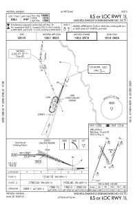
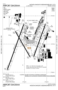
Runways:
| RWY identifier | QFU | Length (ft) | Width (ft) | Surface | LDA (ft) |
| 01R | 20° | 7302 | 150 | CONC | 7302 |
| 19L | 200° | 7302 | 150 | CONC | 7302 |
| 01L | 20° | 10302 | 150 | CONC | 10301 |
| 19R | 200° | 10302 | 150 | CONC | 10301 |
| 14 | 150° | 6301 | 150 | CONC | 6301 |
| 32 | 330° | 6301 | 150 | CONC | 6301 |
Airport contact information
Address: Wichita United States

