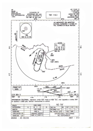


SLCO - Cap. Av. Civ. Anibal Arab Fadul
Located in Cobija, Bolivia
ICAO - SLCO, IATA - CIJ
Data provided by AirmateGeneral information
Coordinates: S11°2'16" W68°46'60"
Elevation is 804 feet MSL.
View others Airports in Pando
Operational data
Special qualification required
Current time UTC:
Current local time:
Weather
METAR: SLCO 101800Z 13008KT 9999 SCT025 32/26 Q1010
TAF: TAF SLCO 101600Z 1018/1118 14006KT 9999 BKN020 TX33/1019Z TN24/1110Z TEMPO 1019/1022 24010KT BECMG 1100/1102 00000KT TEMPO 1108/1112 3000 BR BKN004 BECMG 1113/1114 35010KT
Communications frequencies: [VIEW]
Runways:
| RWY identifier | QFU | Length (ft) | Width (ft) | Surface | LDA (ft) |
| 02 | 11° | 8530 | 148 | ASP | |
| 20 | 191° | 8530 | 148 | ASP |
Airport contact information
Address: Cobija Bolivia