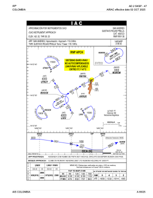
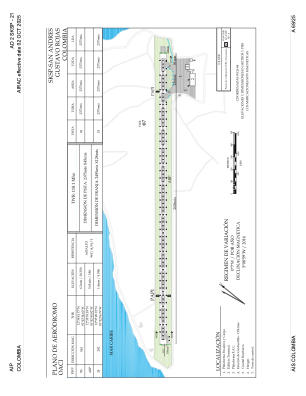


SKSP - San Andres-Gustavo Rojas Pinilla
Located in San Andres, Colombia
ICAO - SKSP, IATA - ADZ
Data provided by AirmateGeneral information
Coordinates: N12°35'1" W81°42'41"
Elevation is 20 feet MSL.
Magnetic variation is -4° East View others Airports in San Andrés Providencia y Santa Catalina
Operational data
Special qualification required
Current time UTC:
Current local time:
Weather
METAR: SKSP 221500Z 07008KT 040V100 9999 FEW018 32/26 Q1012
TAF: TAF SKSP 221030Z 2212/2312 VRB03KT 9999 FEW016 BECMG 2211/2213 06012KT TEMPO 2214/2217 SHRA SCT014TCU TX33/2218Z TN28/2310Z
Communications frequencies: [VIEW]
Runways:
| RWY identifier | QFU | Length (ft) | Width (ft) | Surface | LDA (ft) |
| 06 | 60° | 7792 | 148 | ASPH | 7792 |
| 24 | 240° | 7792 | 148 | ASPH | 7792 |
Airport contact information
Address: San Andres Colombia