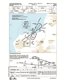
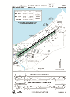


SEMT - Manta / Eloy Alfaro Intl
Located in Manta, Ecuador
ICAO - SEMT, IATA - MEC
Data provided by AirmateGeneral information
Coordinates: S0°56'44" W80°40'42"
Elevation is 49 feet MSL.
Magnetic variation is -3° East View others Airports in Manabi
Operational data
Special qualification required
Current time UTC:
Current local time:
Weather
METAR: SEMT 290500Z 21003KT 9999 SCT020 31/22 Q1011 RMK A2986
TAF: SEMT 290440Z 2906/3006 22005KT 9999 BKN020 BECMG 2914/2916 SCT023 BECMG 2916/2618 29008KT BECMG 3000/3002 22006KT TX31/2920Z TN25/2910Z
Communications frequencies: [VIEW]
Runways:
| RWY identifier | QFU | Length (ft) | Width (ft) | Surface | LDA (ft) |
| 06 | 56° | 9403 | 143 | ASPH | 9390 |
| 24 | 236° | 9403 | 143 | ASPH | 9390 |
Airport contact information
Address: Manta Ecuador