


SCIE - Carriel Sur
Located in Concepcion, Chile
ICAO - SCIE, IATA - CCP
Data provided by AirmateGeneral information
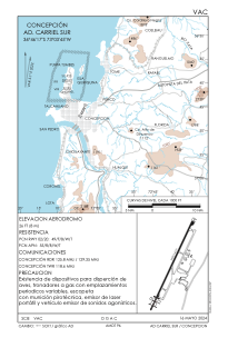
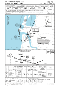
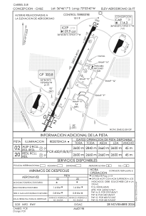
Coordinates: S36°46'17" W73°3'45"
Elevation is 26 feet MSL.
Magnetic variation is 5° East View others Airports in Bío-Bío
Operational data
Special qualification required
Current time UTC:
Current local time:
Weather
METAR: SCIE 272100Z 23007KT 9999 FEW030 14/08 Q1022
TAF: TAF SCIE 271634Z 2718/2818 24013KT 9999 SCT035 TX16/2718Z TN04/2812Z BECMG 2802/2804 18005KT CAVOK BECMG 2808/2810 12004KT TEMPO 2808/2812 VRB02KT 5000 BR NSC BECMG 2814/2816 29004KT FEW010 SCT025
Communications frequencies: [VIEW]
Runways:
| RWY identifier | QFU | Length (ft) | Width (ft) | Surface | LDA (ft) |
| 02 | 25° | 8530 | 148 | ASPH | 8530 |
| 20 | 205° | 8530 | 148 | ASPH | 8530 |
Airport contact information
Address: Concepcion Chile
