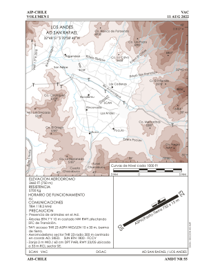


SCAN - San Rafael
Located in Los Andes, Chile
ICAO - SCAN, IATA - LOB
Data provided by AirmateGeneral information
Coordinates: S32°48'51" W70°38'48"
Elevation is 2460 feet MSL.
Magnetic variation is 1° East View others Airports in Valparaíso
Operational data
Special qualification required
Current time UTC:
Current local time:
Weather at : SCEL - Arturo Merino Benitez ( 66 km )
METAR: SCEL 131400Z 30003KT 270V330 5000 HZ NSC 05/03 Q1021 NOSIG
TAF: TAF SCEL 131000Z 1312/1412 VRB02KT 7000 NSC TX16/1319Z TN02/1410Z TEMPO 1312/1314 4000 BR BECMG 1316/1318 21012KT CAVOK BECMG 1402/1404 15004KT 7000 NSC TEMPO 1408/1412 VRB02KT 5000 BR
Communications frequencies: [VIEW]
Runways:
| RWY identifier | QFU | Length (ft) | Width (ft) | Surface | LDA (ft) |
| 05 | 55° | 2465 | 46 | ASPH | |
| 23 | 235° | 2465 | 46 | ASPH |
Airport contact information
Address: Los Andes Chile
