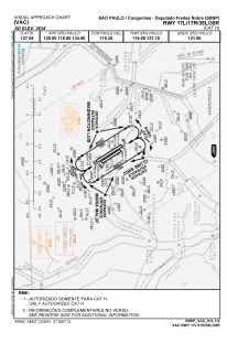
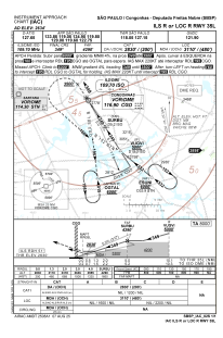
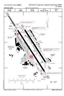


SBSP - Congonhas - Deputado Freitas Nobre
Located in São Paulo, Brazil
ICAO - SBSP, IATA - CGH
Data provided by AirmateGeneral information
Coordinates: S23°37'34" W46°39'23"
Elevation is 2634 feet MSL.
Magnetic variation is -21.75° East View others Airports in São Paulo
Operational data
Special qualification required
Current time UTC:
Current local time:
Weather
METAR: SBSP 131000Z 32008KT 250V350 CAVOK 21/12 Q1016
TAF: TAF SBSP 130900Z 1312/1324 35010KT CAVOK TX31/1318Z TN22/1324Z BECMG 1312/1314 32010KT BECMG 1315/1317 30015KT PROB40 1323/1324 22006KT SCT020 RMK PHG
Communications frequencies: [VIEW]
Runways:
| RWY identifier | QFU | Length (ft) | Width (ft) | Surface | LDA (ft) |
| 17R | 147° | 6572 | 919 | ASPH | |
| 35L | 327° | 6572 | 919 | ASPH | |
| 17L | 147° | 5299 | 492 | ASPH | |
| 35R | 327° | 5299 | 492 | ASPH |
Airport contact information
Address: São Paulo Brazil

