


SBPS - Porto Seguro
Located in Porto Seguro, Brazil
ICAO - SBPS, IATA - BPS
Data provided by AirmateGeneral information
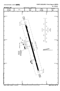
Coordinates: S16°26'17" W39°4'40"
Elevation is 169 feet MSL.
Magnetic variation is -23.769904772° East View others Airports in Bahia
Operational data
Special qualification required
Current time UTC:
Current local time:
Weather
METAR: SBPS 140200Z 36005KT CAVOK 25/23 Q1013
TAF: TAF SBPS 132005Z 1400/1424 07010KT 9999 FEW020 TN24/1409Z TX29/1415Z BECMG 1401/1403 27005KT TEMPO 1406/1410 23003KT 4000 BR SCT004 BKN010 BECMG 1412/1414 07010KT BECMG 1422/1424 04005KT RMK PFV
Communications frequencies: [VIEW]
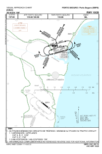
Runways:
| RWY identifier | QFU | Length (ft) | Width (ft) | Surface | LDA (ft) |
| 10 | 74° | 6955 | 919 | ASPH | |
| 28 | 254° | 6955 | 919 | ASPH |
Airport contact information
Address: Porto Seguro Brazil
