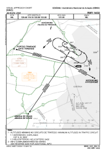


SBNV - Aeródromo Nacional De Aviação
Located in Goiânia, Brazil
ICAO - SBNV, IATA -
Data provided by AirmateGeneral information
Coordinates: S16°37'32" W49°20'58"
Elevation is 2732 feet MSL.
Magnetic variation is -21° East View others Airports in Goiás
Operational data
Special qualification required
Current time UTC:
Current local time:
Weather at : SBGO - Santa Genoveva ( 14 km )
TAF: TAF SBGO 281930Z 2900/2924 09005KT CAVOK TN20/2909Z TX33/2917Z BECMG 2901/2903 00000KT BECMG 2909/2911 08005KT BECMG 2914/2916 05005KT FEW040 BECMG 2919/2921 09005KT CAVOK RMK PGN
Communications frequencies: [VIEW]
Runways:
| RWY identifier | QFU | Length (ft) | Width (ft) | Surface | LDA (ft) |
| 14 | 0° | 3609 | 66 | ASPH | |
| 32 | 0° | 3609 | 66 | ASPH |
Airport contact information
Address: Goiânia Brazil
