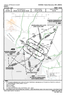
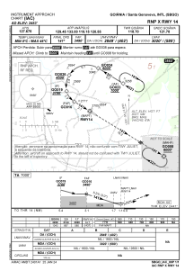
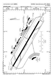


SBGO - Santa Genoveva
Located in Goiânia, Brazil
ICAO - SBGO, IATA - GYN
Data provided by AirmateGeneral information
Coordinates: S16°37'57" W49°13'16"
Elevation is 2453 feet MSL.
Magnetic variation is -21.0° East View others Airports in Goiás
Operational data
Special qualification required
Current time UTC:
Current local time:
Weather
METAR: SBGO 281500Z 33005KT 260V040 9999 SCT045 30/18 Q1018
TAF: TAF SBGO 280800Z 2812/2912 13005KT CAVOK TX32/2817Z TN20/2909Z BECMG 2812/2815 07005KT FEW040 BECMG 2819/2822 13005KT CAVOK BECMG 2902/2905 00000KT BECMG 2909/2912 13005KT RMK PGH
Communications frequencies: [VIEW]
Runways:
| RWY identifier | QFU | Length (ft) | Width (ft) | Surface | LDA (ft) |
| 14 | 120° | 2406 | 280 | ASPH | |
| 32 | 300° | 2406 | 280 | ASPH |
Airport contact information
Address: Goiânia Brazil
