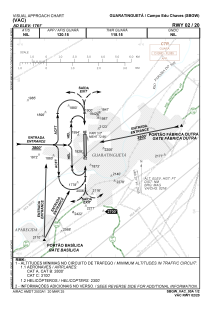
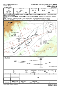
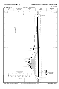


SBGW - Campo Edu Chaves
Located in Guaratinguetá, Brazil
ICAO - SBGW, IATA - GUJ
Data provided by AirmateGeneral information
Coordinates: S22°47'30" W45°12'16"
Elevation is 1761 feet MSL.
Magnetic variation is -22.416666667° East View others Airports in São Paulo
Operational data
Special qualification required
Current time UTC:
Current local time:
Weather
METAR: SBGW 112100Z 32003KT 9999 FEW045 26/15 Q1014
TAF: TAF SBGW 111500Z 1118/1206 23004KT 9999 FEW030 TX29/1118Z TN18/1206Z BECMG 1123/1124 CAVOK RMK PEC
Communications frequencies: [VIEW]
Runways:
| RWY identifier | QFU | Length (ft) | Width (ft) | Surface | LDA (ft) |
| 02 | 0° | 5089 | 98 | ASPH | |
| 20 | 0° | 5089 | 98 | ASPH |
Airport contact information
Address: Guaratinguetá Brazil