


RORE - Iejima
Located in , Japan
ICAO - RORE, IATA - IEJ
Data provided by AirmateGeneral information
Coordinates: N26°43'21" E127°47'13"
Elevation is 238 feet MSL.
View others Airports in Okinawa Prefecture
Operational data
Special qualification required
Current time UTC:
Current local time:
Weather at : RODN - Kadena ( 41 km )
METAR: RODN 111455Z 15007KT 10SM BKN170 25/21 A2996 RMK AO2A SLP151 T02470214 402740219 58004 PWINO FZRANO TSNO $
TAF: TAF RODN 110800Z 1108/1214 16010KT 9999 SCT030 BKN160 QNH2990INS BECMG 1200/1201 18012G18KT 9999 VCSH BKN025 QNH2987INS BECMG 1206/1207 19012KT 9000 -SHRA BKN020 OVC030 QNH2985INS TEMPO 1207/1210 4800 -TSRA BKN010 OVC020CB BECMG 1211/1212 23010KT 6000 -RA BR BKN010 OVC020 QNH2984INS TX29/1203Z TN22/1117Z
Communications frequencies: [VIEW]
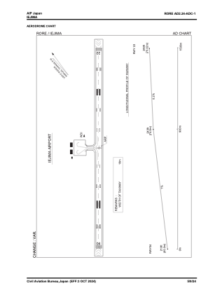
Runways:
| RWY identifier | QFU | Length (ft) | Width (ft) | Surface | LDA (ft) |
| 04 | 39° | 4920 | 150 | ASP | |
| 22 | 219° | 4920 | 150 | ASP |
Airport contact information
Address: Japan