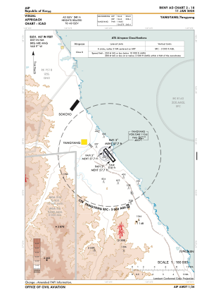

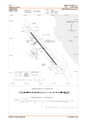


RKNY - Yangyang / International
Located in Yangyang, Korea, Republic of
ICAO - RKNY, IATA - YNY
Data provided by AirmateGeneral information
Coordinates: N38°3'41" E128°40'9"
Elevation is 241 feet MSL.
Magnetic variation is -9° East View others Airports in Gang'weondo
Operational data
Special qualification required
Current time UTC:
Current local time:
Weather
METAR: RKNY 162200Z 25007KT 210V300 CAVOK 16/05 Q1011 WS ALL RWY NOSIG
TAF: TAF RKNY 161700Z 1618/1724 27015G25KT CAVOK TN15/1620Z TX26/1706Z TN19/1720Z BECMG 1622/1624 26007KT BECMG 1702/1704 26015G25KT BECMG 1707/1709 26008KT BECMG 1712/1714 27018G35KT
Communications frequencies: [VIEW]
Runways:
| RWY identifier | QFU | Length (ft) | Width (ft) | Surface | LDA (ft) |
| 15 | 141° | 8202 | 148 | CON | |
| 33 | 321° | 8202 | 148 | CON |
Airport contact information
Address: Yangyang Korea, Republic of