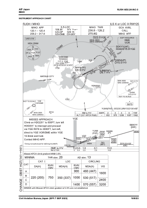


RJOH - Miho
Located in Yonago, Japan
ICAO - RJOH, IATA - YGJ
Data provided by AirmateGeneral information
Coordinates: N35°29'36" E133°14'21"
Elevation is 13 feet MSL.
View others Airports in Shimane Prefecture
Operational data
Special qualification required
Current time UTC:
Current local time:
Weather
METAR: RJOH 121000Z 31004KT 8000 SHRA FEW020 BKN030 BKN050 19/18 Q1008
TAF: TAF RJOH 120505Z 1206/1312 20005KT 8000 -SHRA FEW005 SCT015 BKN030 TEMPO 1206/1209 4000 SHRA BR FEW003 BKN008 BKN015 TEMPO 1209/1215 3000 SHRA BR FEW001 SCT003 BKN005 BECMG 1303/1306 05008KT
Communications frequencies: [VIEW]
Runways:
| RWY identifier | QFU | Length (ft) | Width (ft) | Surface | LDA (ft) |
| 07 | 64° | 8202 | 148 | ASP | |
| 25 | 244° | 8202 | 148 | ASP |
Airport contact information
Address: Yonago Japan