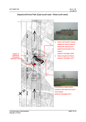


RCH15 - Kaohsiung Emergency Operation Center
Located in Kaohsiung, Taiwan, Province of China
ICAO - , IATA -
Data provided by AirmateGeneral information
Coordinates: N22°35'37" E120°18'26"
Elevation is 160 feet MSL.
Magnetic variation is -4° East View others Airports in Kaohsiung (municipality)
Operational data
Special qualification required
Current time UTC:
Current local time:
Weather at : RCKH - Kaohsiung Intl ( 5 km )
TAF: TAF RCKH 171700Z 1718/1824 06005KT 9999 FEW020 SCT080 BECMG 1801/1803 28010KT TEMPO 1806/1811 33008KT BECMG 1811/1813 06005KT TEMPO 1819/1823 5000 BR
Communications frequencies: [VIEW]
Runways:
Airport contact information
Address: Kaohsiung Taiwan, Province of China