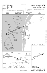
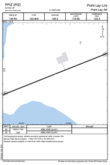


PPIZ - Point Lay Lrrs
Located in Point Lay,
ICAO - PIZ, IATA - PIZ
Data provided by AirmateGeneral information
Coordinates: N69°43'58" W163°0'19"
Elevation is 29 feet MSL.
Magnetic variation is 15° East View others Airports in Alaska
Operational data
Special qualification required
Current time UTC:
Current local time:
Weather
METAR: PPIZ 101656Z AUTO 26004KT 9SM -SN FEW015 OVC065 M06/M08 A2992 RMK AO2 SLP133 P0000 T10611083 FZRANO
Communications frequencies: [VIEW]
Runways:
| RWY identifier | QFU | Length (ft) | Width (ft) | Surface | LDA (ft) |
| 05 | 69° | 4500 | 100 | GRAVE | |
| 23 | 249° | 4500 | 100 | GRAVE |
Airport contact information
Address: Point Lay