


PHMK - Molokai
Located in Kaunakakai,
ICAO - MKK, IATA - MKK
Data provided by AirmateGeneral information
Coordinates: N21°9'10" W157°5'47"
Elevation is 454 feet MSL.
Magnetic variation is 11° East View others Airports in Hawaii
Operational data
Special qualification required
Current time UTC:
Current local time:
Weather
METAR: PHMK 121916Z 02008KT SCT026 27/18 A3002 RMK AO2 T02720183 $
TAF: PHMK 121848Z 1219/1318 VRB05KT P6SM FEW025 FM122200 02007G16KT P6SM VCSH FEW030 BKN050 FM130500 VRB04KT P6SM FEW030 SCT050 AMD NOT SKED
Communications frequencies: [VIEW]
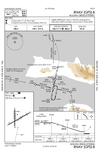
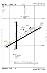
Runways:
| RWY identifier | QFU | Length (ft) | Width (ft) | Surface | LDA (ft) |
| 05 | 60° | 4494 | 100 | ASPH | 4494 |
| 23 | 240° | 4494 | 100 | ASPH | 3901 |
| 17 | 180° | 3118 | 100 | ASPH | 2692 |
| 35 | 0° | 3118 | 100 | ASPH | 3118 |
Airport contact information
Address: Kaunakakai