


PHJR - Kalaeloa (John Rodgers Fld)
Located in Kapolei,
ICAO - JRF, IATA - JRF
Data provided by AirmateGeneral information
Coordinates: N21°18'26" W158°4'13"
Elevation is 30 feet MSL.
Magnetic variation is 11° East View others Airports in Hawaii
Operational data
Special qualification required
Current time UTC:
Current local time:
Weather
METAR: PHJR 101553Z AUTO 06004KT 10SM FEW002 18/17 A2995 RMK AO2 SLP149 T01830167 TSNO
TAF: PHJR 101130Z 1012/1112 VRB05KT 6SM -SHRA SCT025 BKN040 FM101900 18009KT 6SM -SHRA VCTS SCT020CB BKN040 FM110500 VRB04KT 6SM -SHRA SCT020 OVC035
Communications frequencies: [VIEW]
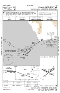
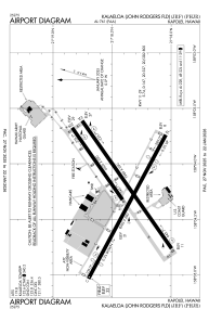
Runways:
| RWY identifier | QFU | Length (ft) | Width (ft) | Surface | LDA (ft) |
| 04L | 55° | 4500 | 200 | ASPH | |
| 22R | 235° | 4500 | 200 | ASPH | |
| 04R | 55° | 8000 | 200 | ASPH | |
| 22L | 235° | 8000 | 200 | ASPH | |
| 11 | 118° | 6000 | 200 | ASPH | |
| 29 | 298° | 6000 | 200 | ASPH |
Airport contact information
Address: Kapolei
