


PGUA - Andersen Afb
Located in Yigo, Guam
ICAO - UAM, IATA - UAM
Data provided by AirmateGeneral information
Coordinates: N13°35'2" E144°55'48"
Elevation is 617 feet MSL.
Magnetic variation is 02° East View others Airports in (unassigned)
Operational data
Special qualification required
Current time UTC:
Current local time:
Weather
METAR: PGUA 191210Z AUTO 06011KT 6SM BR SCT014 BKN023 27/25 A2987 RMK AO2 CIG 014V023 BKN V OVC SLP105 $
TAF: TAF PGUA 191000Z 1910/2016 06015KT 9999 SCT015 SCT025 QNH2979INS TEMPO 1916/1922 07015G20KT 6000 -SHRA BKN010 TX31/1903Z TN26/1918Z
Communications frequencies: [VIEW]
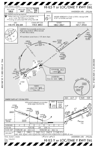
Runways:
| RWY identifier | QFU | Length (ft) | Width (ft) | Surface | LDA (ft) |
| 06L | 0° | 10528 | 200 | CONC+ASPH | |
| 24R | 0° | 10528 | 200 | CONC+ASPH | |
| 06R | 0° | 11200 | 200 | CONC+ASPH | |
| 24L | 0° | 11200 | 200 | CONC+ASPH |
Airport contact information
Address: Yigo Guam