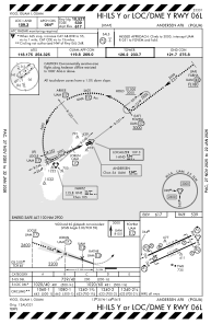


PGUA - Andersen Afb
Located in Yigo, Guam
ICAO - UAM, IATA - UAM
Data provided by AirmateGeneral information
Coordinates: N13°35'2" E144°55'48"
Elevation is 617 feet MSL.
Magnetic variation is 02° East View others Airports in (unassigned)
Operational data
Special qualification required
Current time UTC:
Current local time:
Weather
METAR: PGUA 062255Z AUTO 05009KT 10SM FEW017 28/23 A2988 RMK AO2 SLP109 T02800229
TAF: TAF PGUA 061800Z 0618/0724 05010KT 9999 FEW015 QNH2980INS TEMPO 0620/0702 06010G15KT 6000 -SHRA BKN012 TX30/0702Z TN26/0618Z
Communications frequencies: [VIEW]
Runways:
| RWY identifier | QFU | Length (ft) | Width (ft) | Surface | LDA (ft) |
| 06L | 0° | 10528 | 200 | CONC+ASPH | |
| 24R | 0° | 10528 | 200 | CONC+ASPH | |
| 06R | 0° | 11200 | 200 | CONC+ASPH | |
| 24L | 0° | 11200 | 200 | CONC+ASPH |
Airport contact information
Address: Yigo Guam