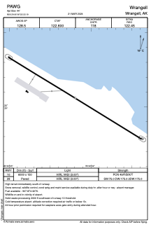


PAWG - Wrangell
Located in Wrangell,
ICAO - WRG, IATA - WRG
Data provided by AirmateGeneral information
Coordinates: N56°29'4" W132°22'11"
Elevation is 44 feet MSL.
Magnetic variation is 20° East View others Airports in Alaska
Operational data
Special qualification required
Current time UTC:
Current local time:
Weather
TAF: PAWG 100532Z 1006/1106 09006G16KT 6SM -RA BR BKN020 BKN035 OVC050 FM101200 27006KT P6SM OVC025 FM101500 28005KT P6SM OVC050 AMD NOT SKED 1006/1015
Communications frequencies: [VIEW]
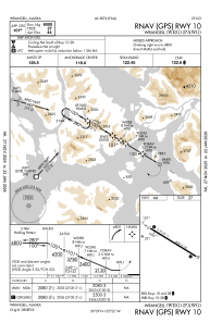
Runways:
| RWY identifier | QFU | Length (ft) | Width (ft) | Surface | LDA (ft) |
| 10 | 121° | 6000 | 150 | ASPH | |
| 28 | 301° | 6000 | 150 | ASPH |
Airport contact information
Address: Wrangell