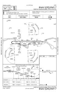
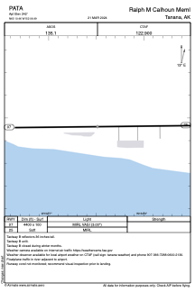


PATA - Ralph M Calhoun Meml
Located in Tanana,
ICAO - TAL, IATA - TAL
Data provided by AirmateGeneral information
Coordinates: N65°10'28" W152°6'29"
Elevation is 242 feet MSL.
Magnetic variation is 19° East View others Airports in Alaska
Operational data
Special qualification required
Current time UTC:
Current local time:
Weather
METAR: PATA 100852Z AUTO 00000KT FEW055 OVC070 04/00 A2977 RMK AO2 SLP084 T00440000 400941006 53018 TSNO $
TAF: PATA 100523Z 1006/1106 26005KT P6SM FEW040 BKN100 FM101100 31003KT P6SM SKC
Communications frequencies: [VIEW]
Runways:
| RWY identifier | QFU | Length (ft) | Width (ft) | Surface | LDA (ft) |
| 07 | 89° | 4400 | 100 | GRAVEL | |
| 25 | 269° | 4400 | 100 | GRAVEL |
Airport contact information
Address: Tanana