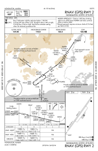


PANO - Nondalton
Located in Nondalton,
ICAO - 5NN, IATA -
Data provided by AirmateGeneral information
Coordinates: N59°58'49" W154°50'21"
Elevation is 314 feet MSL.
Magnetic variation is 14° East View others Airports in Alaska
Operational data
Special qualification required
Current time UTC:
Current local time:
Weather at : PAIL - Iliamna ( 25 km )
METAR: PAIL 101453Z 08013G26KT 10SM SCT040 M01/M01 A2989 RMK AO2 PK WND 08026/1445 SLP125 T10061006 55001 $
TAF: PAIL 101138Z 1012/1112 08008KT P6SM BKN150 FM101600 08015G25KT P6SM BKN100 FM102000 09022G30KT P6SM VCSH OVC050 FM102200 09025G35KT 6SM -RA SCT025 OVC035 FM110400 09020G27KT P6SM VCSH OVC040
Communications frequencies: [VIEW]
Runways:
| RWY identifier | QFU | Length (ft) | Width (ft) | Surface | LDA (ft) |
| 02 | 38° | 2800 | 75 | GRAVEL | |
| 20 | 218° | 2800 | 75 | GRAVEL |
Airport contact information
Address: Nondalton