


PANO - Nondalton
Located in Nondalton,
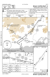
ICAO - 5NN, IATA -
Data provided by AirmateGeneral information
Coordinates: N59°58'49" W154°50'21"
Elevation is 314 feet MSL.
Magnetic variation is 14° East View others Airports in Alaska
Operational data
Special qualification required
Current time UTC:
Current local time:
Communications frequencies: [VIEW]
Runways:
| RWY identifier | QFU | Length (ft) | Width (ft) | Surface | LDA (ft) |
| 02 | 38° | 2800 | 75 | GRAVEL | |
| 20 | 218° | 2800 | 75 | GRAVEL |
Airport contact information
Address: Nondalton