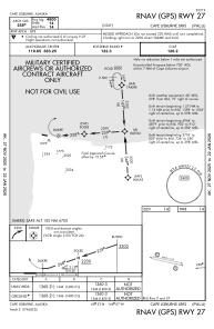


PALU - Cape Lisburne Lrrs
Located in Cape Lisburne,
ICAO - LUR, IATA - LUR
Data provided by AirmateGeneral information
Coordinates: N68°52'30" W166°6'40"
Elevation is 14 feet MSL.
Magnetic variation is 07° East View others Airports in Alaska
Operational data
Special qualification required
Current time UTC:
Current local time:
Weather
METAR: PALU 110355Z AUTO 30004KT 10SM OVC008 M04/M05 A2997 RMK AO2 SHSNB0316E0318 SLP147 T10431052
Communications frequencies: [VIEW]
Runways:
| RWY identifier | QFU | Length (ft) | Width (ft) | Surface | LDA (ft) |
| 09 | 101° | 4800 | 135 | GRAVEL | |
| 27 | 281° | 4800 | 135 | GRAVEL |
Airport contact information
Address: Cape Lisburne