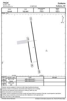


PAGK - Gulkana
Located in Gulkana,
ICAO - GKN, IATA - GKN
Data provided by AirmateGeneral information
Coordinates: N62°9'16" W145°27'19"
Elevation is 1586 feet MSL.
Magnetic variation is 17° East View others Airports in Alaska
Operational data
Special qualification required
Current time UTC:
Current local time:
Weather
TAF: PAGK 191441Z 1915/2012 12005KT P6SM OVC090 FM191800 16007KT P6SM -RA OVC045 FM192300 17008KT P6SM SCT045 OVC070 FM200600 17007KT 5SM -RA SCT015 BKN025
Communications frequencies: [VIEW]
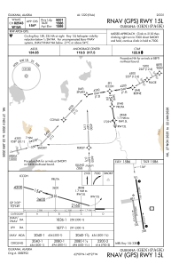
Runways:
| RWY identifier | QFU | Length (ft) | Width (ft) | Surface | LDA (ft) |
| 15L | 171° | 5001 | 100 | ASPH | |
| 33R | 351° | 5001 | 100 | ASPH | |
| 15R | 171° | 2300 | 60 | GRAVEL | |
| 33L | 351° | 2300 | 60 | GRAVEL |
Airport contact information
Address: Gulkana