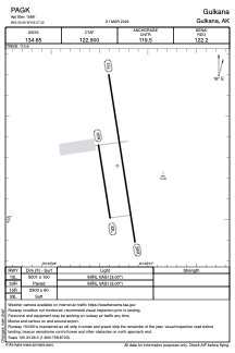


PAGK - Gulkana
Located in Gulkana,
ICAO - GKN, IATA - GKN
Data provided by AirmateGeneral information
Coordinates: N62°9'16" W145°27'19"
Elevation is 1586 feet MSL.
Magnetic variation is 17° East View others Airports in Alaska
Operational data
Special qualification required
Current time UTC:
Current local time:
Weather
METAR: PAGK 121453Z AUTO 03004KT 10SM FEW043 OVC055 03/M01 A2956 RMK AO2 SLP023 T00331006 56002 TSNO $
TAF: PAGK 121120Z 1212/1312 VRB04KT P6SM OVC080 FM122200 18010G18KT P6SM VCSH SCT060 BKN090 FM130600 17007KT P6SM SCT070 BKN100
Communications frequencies: [VIEW]
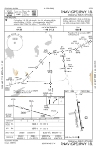
Runways:
| RWY identifier | QFU | Length (ft) | Width (ft) | Surface | LDA (ft) |
| 15L | 171° | 5001 | 100 | ASPH | |
| 33R | 351° | 5001 | 100 | ASPH | |
| 15R | 171° | 2300 | 60 | GRAVEL | |
| 33L | 351° | 2300 | 60 | GRAVEL |
Airport contact information
Address: Gulkana