


O35 - Hollis Muni
Located in Hollis, United States
ICAO - O35, IATA -
Data provided by AirmateGeneral information
Coordinates: N34°42'19" W99°54'31"
Elevation is 1659 feet MSL.
Magnetic variation is 05° East View others Airports in Oklahoma
Operational data
Special qualification required
Current time UTC:
Current local time:
Weather at : KCDS - Childress Muni ( 46 km )
TAF: KCDS 192327Z 2000/2024 18020G30KT P6SM SKC FM200600 19011KT P6SM SKC WS008/19045KT FM201100 20011KT P6SM SKC
Communications frequencies: [VIEW]
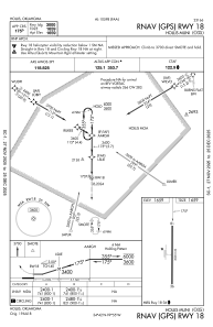
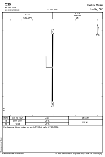
Runways:
| RWY identifier | QFU | Length (ft) | Width (ft) | Surface | LDA (ft) |
| 18 | 180° | 3000 | 60 | ASPH | |
| 36 | 0° | 3000 | 60 | ASPH |
Airport contact information
Address: Hollis United States