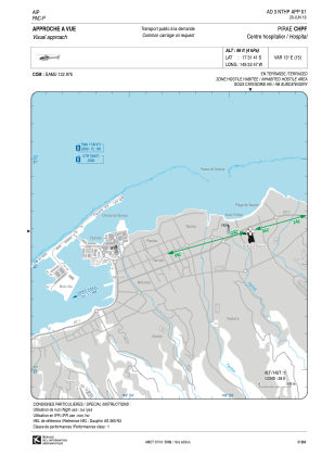


NTHP - Pirae Chpf
Located in , French Polynesia
ICAO - , IATA -
Data provided by AirmateGeneral information
Coordinates: S17°31'41" W149°32'47"
Elevation is 96 feet MSL.
Magnetic variation is 12.94° East View others Airports in (unassigned)
Operational data
Special qualification required
Current time UTC:
Current local time:
Weather at : NTAA - Tahiti Faa'a ( 8 km )
METAR: NTAA 132000Z VRB02KT 9999 VCSH FEW025 BKN040 29/24 Q1016 NOSIG
TAF: TAF NTAA 131700Z 1318/1424 VRB05KT 9999 FEW023 PROB30 TEMPO 1321/1403 05010KT
Communications frequencies: [VIEW]
Runways:
Airport contact information
Address: French Polynesia