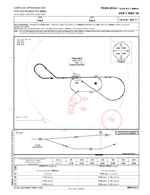
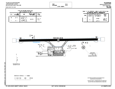


MMPA - Poza Rica Aeropuerto Nacional Tajin
Located in Poza Rica, Mexico
ICAO - MMPA, IATA - PAZ
Data provided by AirmateGeneral information
Coordinates: N20°36'8" W97°27'38"
Elevation is 497 feet MSL.
View others Airports in Veracruz
Operational data
Special qualification required
Current time UTC:
Current local time:
Weather
TAF: TAF MMPA 100543Z 1006/1106 00000KT 5SM HZ SCT080 BKN250 BECMG 1010/1011 4SM HZ BKN250 FM101500 06005KT 6SM HZ OVC250 BECMG 1020/1021 08012KT
Communications frequencies: [VIEW]
Runways:
| RWY identifier | QFU | Length (ft) | Width (ft) | Surface | LDA (ft) |
| 08 | 89° | 5922 | 148 | ASP | |
| 26 | 269° | 5922 | 148 | ASP |
Airport contact information
Address: Poza Rica Mexico